 Today I’ve got a really important survival skill to share…
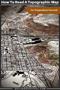
A Complete Guide To Using A Topographical Map For Survival
These amazing maps include a treasure trove of valuable information.
- Topo maps are essential for planning off-road routes.
- And a must-have in the heat of battle.
But they’re worthless IF you don’t know what the lines and symbols mean.
TOPICS IN THIS GUIDE… ↓(click to jump)
- What Is A Topographic Map?
- Why You Should Own Them
- How To Read A Topographic Map
- Best Topographic Maps For Sale
- How To Print A Paper Map Online

What Is A Topographical Map?
Topographic is the adjective form of the noun topography.
This refers to the land’s surface features.
Topographic maps are sometimes called topo maps for short.
It’s a way to show three-dimensional terrain in 2-dimensional form.
So a topo map indicates unique land features, such as:
- Mountains
- Hills
- Valleys
- And Cliffs
This is typically done with wavy lines representing elevation.
↓ REI – How To Read A Topo Map

Want a free 78 item preppers checklist?
Enter your email below to instantly download this Complete Checklist PDF. No purchase necessary. 👇 👇Why You Should Invest In Topographic Maps
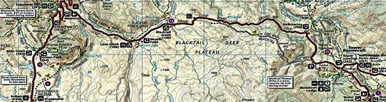
Topographic maps are frequently used by hikers to navigate their routes.
But they’re used more than just for recreation.
For example:
They’re often used by surveyors, architects, biologists, paleontologists, hunting outfitters, etc.
Essentially they’re for anyone who needs to know detailed terrain information.
They are also an ideal tool for making bug-out escape plans.
They help create multiple escape routes out of a city by avoiding dangerous terrain (such as steep ravines or cliffs).
But these maps show you the best routes to stay hidden.
But they’re NOT intuitive to read or understand the first time you see one.
↓ How To Read A Topo Map

Want a free 54 item survival gear checklist?
Enter your email below to instantly download this Complete Checklist PDF. No purchase necessary. 👇 👇How To Read A Topographic Map
To understand how to read a topo map, you must first learn the main features:
- Contour Lines
- Colors
- Shading
Again, the primary goal of topo maps is to represent the shape of the earth in 2 dimensions.
But it also includes additional info such as streets, trails, vegetation, and water sources (lakes, streams, swamps, etc.).
Plus, a few other terrain features to navigate and travel through.
So let’s break down each factor in more detail and with visual examples.
Contour Lines | Map Scales
The key to understanding contour lines on the map is to realize they don’t exist in nature.
Contour lines are NOT paths or trails.
They are a symbolic lines that represent a constant elevation above sea level.
So if a contour line reads at 600 feet above sea level, everywhere that line goes is 600 feet above sea level.
For example:
If you walked this “imaginary/symbolic” path, you would not be pointing uphill or pointing downhill.
Theoretically, your hike would remain at a constant flat elevation.
A nice leisurely flat stroll.
But again, these lines are not real trails or roads.
They represent constant elevation, no more, no less.
Now, there are different types of contour lines.
Index Lines
There are lines that are darker in color.
These are known as index contour lines.
These typically include an elevation number associated with them.
For most topographical maps, every 5th contour line is an index.
Intermediate Lines
Between index contour lines, you have intermediate contour lines.
These lines serve the same function as index lines.
Except they don’t include an elevation number.
Not providing the elevation number with intermediate contour lines is done for purposes of clarity.
Because the more lines the easier it is to visualize elevation changes.
But the map would quickly become a cluttered mess if every contour line was numbered.
Making it impossible to read.
So intermediate contour lines fill in the gaps between the index contour lines.
These extra contour lines provide a better visual representation of a terrain’s elevation without unnecessary clutter.
Supplementary Lines
Finally, there is a third variety of contour lines called supplementary contour lines.
These lines are only used on maps or in very flat regions with very few elevation changes.
These dashed lines represent an elevation that’s halfway between two intermediate contour lines.
Without supplementary contour lines, there would be no contour lines in flat areas.
However, if there’s some elevation change, the supplementary contour lines will show that.
Just remember this:
The closer the contour lines are to each other, the more rapid the change in elevation.
When contour lines are far apart, the terrain is flat – think leisurely stroll.
But, if the lines are packed and stacked right next to each other, you’re looking at a cliff.
If they are moderately spaced, but you’ll cross several in a mile-long hike, it’s not a cliff.
But it’s still going to take some work to hike.
Here’s an example of using topographic contour lines:
Colors
The colors on most topographic maps tell you something about the terrain.
In general, brown is used for the color of the contour lines.
- Green represents vegetation areas such as woods or forest areas.
- Blue denotes water and features (lakes, rivers, streams, swamps, oceans, etc.).
One exception to note is at high elevations; some contour lines may be drawn in blue.
These blue lines represent locations with year-round snowcapped areas or glaciers.
Assume these areas require special gear to transverse, such as pickaxes, crampons, etc.
Finally, the color black is used to denote man-made objects, including trails.
- Red represents man-made features such as roads and boundaries.
- Purple is used to note updates or changes to the map from a previous rendition.
Here’s an example using topographic colors:
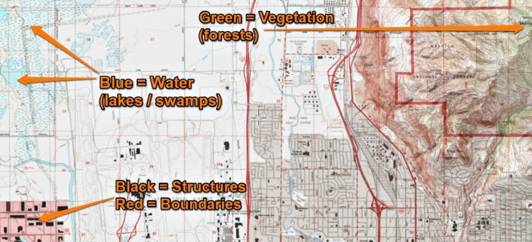
Public lands vs. private lands may also be a unique color to designate that difference.
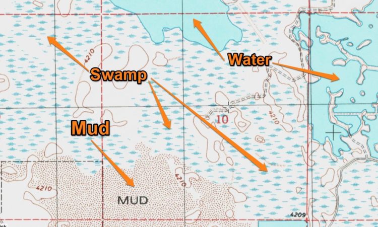
Shading
Topo maps use lots of subtle shading changes to denote slightly different terrain.
For example:
There are several varieties of swampland, each different:
- Marsh or swamp
- Submerged marsh or swamp
- Wooded marsh or swamp
- Submerged wooded marsh or swamp
- Land subject to inundation
The main thing is to keep USGS Topographical Map Symbols handy for quick reference.
That’s easier than trying to memorize each slightly different shading variation.
Putting It All Together
Now it’s time to put this new knowledge to practice.
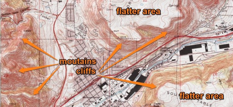
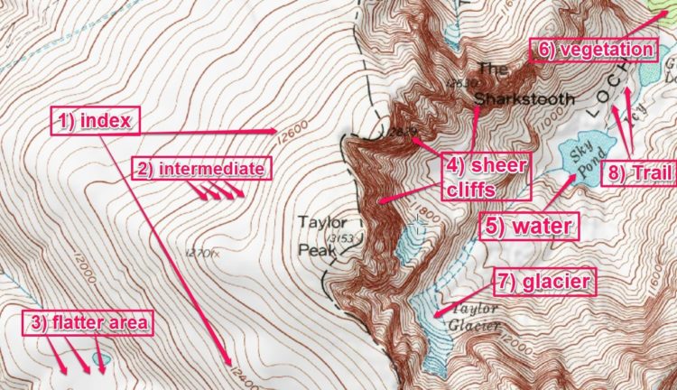
Let’s take a look at 2 examples that have a lot going on.
This first one is in the heart of the Rocky Mountains.
As you can see in this example: 1) index contours, 2) intermediate contours, 3) flatter areas, 4) sheer cliffs, 5) water, 6) vegetation (forest), 7) glacier, and 8) hiking trail.
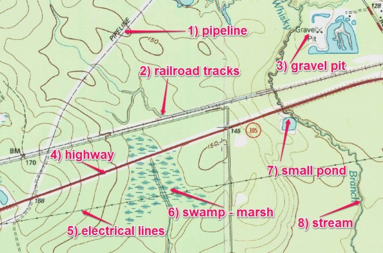
This second example is from the swamplands of Texas.
Notice how much flatter this area of the US is, especially compared to the Rocky Mountains.
As you can see in this example: 1) a pipeline 2) railroad tracks 3) a gravel pit 4) a highway 5) electrical lines 6) a swamp 7) a small pond and 8) a stream.
Now that you understand how to read a topographic map, it’s time to get your hands on some maps to practice your new survival skill.
Want a free 54 item survival gear checklist?
Enter your email below to instantly download this Complete Checklist PDF. No purchase necessary. 👇 👇Best Topographic Maps On The Market Today
First off, I want to say, “I love my topographic maps.”
I’ve found myself pouring over them for hours, looking at all the trails and ravines, overlooks, and cliff edges.
It’s fascinating to me.
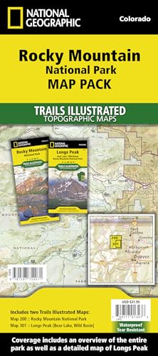
And over the years, I’ve invested in what I consider THE BEST Topo maps – The Trails Illustrated Series.
National Geographic Trails Illustrated Map Series
![]() Trails Illustrated Topo maps are both waterproof and tear-resistant.
Trails Illustrated Topo maps are both waterproof and tear-resistant.
They look and feel like quality and can take a beating from the elements.
They are a must-own if you’re a serious hiker, backpacker, mountain climber, or mountain biker.
Here’s the list of Trails Illustrated Topo Maps I own:
- Maroon Bells, Redstone, Marble
- Rocky Mountain National Park
- Pisgah Ranger District
- Yosemite National Park
- Glacier Waterton Lakes National Parks
- Indian Peaks, Gold Hill
- Tarryall Mts., Kenosha Pass
I own several that cover the area surrounding where I live, and I also buy one anytime I’m about to visit a national park.
They are the “gold standard” of topographic maps; if you can find one for your local area, get it!
↓ Exploring Trails Illustrated National Geographic Topo Maps
Delorme Atlas & Gazetteer State Topographic Maps

![]() Now, if you can’t find Trails Illustrated for your local area, your next best option is Delorme Atlas & Gazetteer State Topographic Maps.
Now, if you can’t find Trails Illustrated for your local area, your next best option is Delorme Atlas & Gazetteer State Topographic Maps.
These maps are broken down by state, and each page is a sub-section of part of the state.
This feature means the map covers A LOT of areas but also allows for enough detail to be helpful.
Plus, these maps offer simple elevation lines and shading in order to give you decent topographic information.
![]()
↓ How NOT To Get Lost – Review DeLorme State Atlas!
Want a free 78 item preppers checklist?
Enter your email below to instantly download this Complete Checklist PDF. No purchase necessary. 👇 👇How To Print A Paper Map Online
If you can’t find a Trails Illustrated Topo Map, I recommend you print topographical map sections for your local area.
Then venture out and begin associating your actual terrain to your topographical map.
Practicing will help you understand what the map is trying to tell you.
The good news is:
Nowadays, getting your hands on topographic map data is both easy and free.
You can find an excellent source of free topo maps here.
Once there, this is what you’ll see:
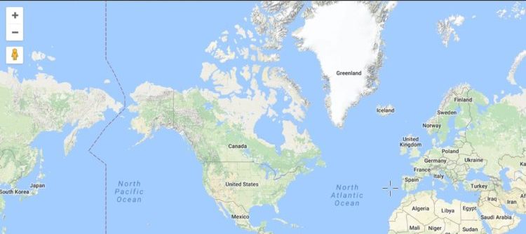
Now use the Zoom In / Zoom Out buttons and click/drag to scroll around.
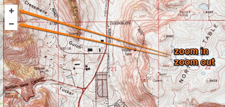
Once you have the data you want on the screen, you can either use a “print screen” button on your computer or any screen capture app to print off what you see.
Final Thoughts
Topo maps are perfect for survival and preparedness planning.
They are essential if you’re planning a bug-out route and also necessary for planning get-home routes.
Heck, they are perfect for any future outdoor adventure.
Using a topo map will make your next hike, backpack, or hunt that much better.
Topographical maps help you steer clear of terrain that would put you in a bad situation.
Learning how to read a topographic map can save lives.

Prepare, Adapt & Overcome,

P.s. - I just found out 2 out of 3 Americans don’t feel prepared for a 3 day disaster!!!
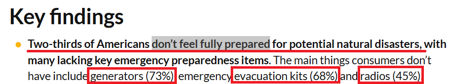
I guess this goes to show how modern society continues to embrace ‘living a fragile life.’ What’s crazy is… it’s so easy to fix.
To make sure YOU have the basics, watch our FREE training on “10 Simple Steps To Basic Preparedness” that shows you HOW.
Nothing crazy here… this isn’t doomsday prepping... just the basics every responsible adult should have before a disaster strikes.Why You Can Trust Skilled Survival...
Go here now to review a full breakdown of:
- Who We Are
- Our Credentials
- Our Mission
- & Product Recommendations...
Here are a few highlights of our teams credentials & certifications:
- Certified Member of a Mountain Search & Rescue Organization
- Plant Emergency & Safety Leader for a Major Food Manufacturer
- Member of the 10TH Mountain Division Hut Association
- Certifications: Avalanche 1, WFR, CPR
- Official Gear Tester for Numerous Outdoor Gear Companies
- Countless Multiday Backpacking trips into Remote Wilderness
- Bachelor's Degree In Mechanical Engineering
- Bachelor's Degree In Civil Engineering
- Bachelor's Degree In Biomedical Engineering
"It takes 20 years to build a reputation and five minutes to ruin it." - Warren Buffett
We're fully aware that trust is NOT something you GET but is EARNED.
And we'll continue to earn YOUR trust through our forthright and honest approach with each new Blog Post, Guide & Product we create...
P.s - I just took this FREE 60-second 'Readiness Score Quiz'👇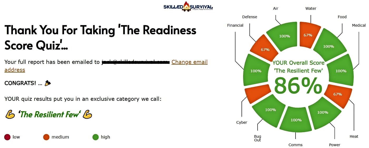
AND... I've still got a few gaps in my preps...🤔 But at least, I'm not part of 'The Fragile Masses'. 👍 Find out where YOU stand by answering a few questions...